°M
NM
NM
hh:mm
hh:mm
Procedure
ft/kts/angle
MHz/kHz/Cha.
NM
°T
lbs
gal
°M/kts
kts
ft
ft
Ident/Freq./Dist./Bearing
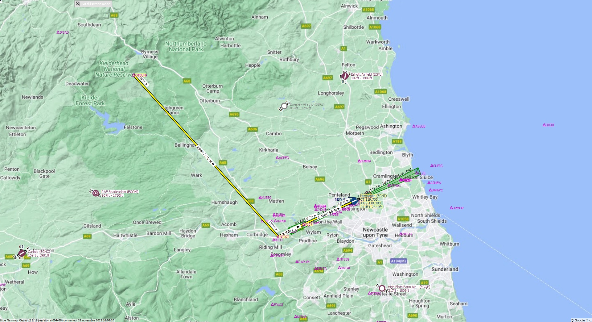
Cruising altitude 7.000 ft.
Distance 35 NM.
Clearance: British Landor 3 1 0, you are cleared for Necastle runway 07 approach. Fly heading 1 3 9 toward NT07I Fix. At NT07I turn left to align with 07 runway. Maintain 7000 feet.
Flight Plan Remarks
| FS Approaches UK Airports EGNT - Newcastle Aircraft: Airbus A310 City: Newcastle Elevation: 251 ft Magnetic declination: 0,4° West Runway 07 Size: 7.642 x 148 ft Surface: Asphalt Pattern Altitude: 1.000 ft Edge Lights: High Center Lights: Low Runway Markings: Edges, Threshold, Fixed Distance, Touchdown, Dashes, Ident, Precision, Alternate Fixed Distance, Alternate Touchdown TTS Welcome to FS Approaches Adventures! British Landor 3 1 0, you are cleared for Necastle runway 07 approach. Fly heading 1 3 9 toward NT07I Fix. At NT07I turn left to align with 07 runway. Maintain 7000 feet. Good day. |
| Ident | Name | Course °M |
Distance NM |
Remarks | Remaining NM |
Leg Time hh:mm |
Procedure | ETA hh:mm |
Region | Airway or Procedure |
Restriction ft/kts/angle |
Type | Freq. MHz/kHz/Cha. |
Range NM |
Course °T |
Fuel Rem. lbs |
Fuel Rem. gal |
Wind °M/kts |
Head- or Tailwind kts |
Altitude ft |
Leg Safe Alt. ft |
Latitude | Longitude | Related Ident/Freq./Dist./Bearing |
|
|---|---|---|---|---|---|---|---|---|---|---|---|---|---|---|---|---|---|---|---|---|---|---|---|---|---|
| OTBUN | 0,0 | 35 | Departure | EG | 55° 16' 50,00" N | 2° 26' 0,00" W | |||||||||||||||||||
| NT07I | 139 | 25 | 9,7 | EG | 138 | 54° 58' 10,43" N | 1° 56' 45,54" W | ||||||||||||||||||
| FI07 | 65 | 3,3 | 6,4 | EG | 64 | 54° 59' 36,67" N | 1° 51' 36,88" W | ||||||||||||||||||
| EGNT | Newcastle | 66 | 6,4 | 310 | 0,0 | Destination | EG | 65 | 55° 2' 17,00" N | 1° 41' 23,02" W |
| Links |