°M
NM
NM
hh:mm
hh:mm
Procedure
ft/kts/angle
MHz/kHz/Cha.
NM
°T
lbs
gal
°M/kts
kts
ft
ft
Ident/Freq./Dist./Bearing
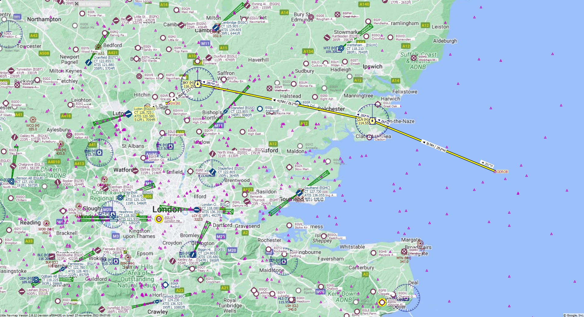
Cruising altitude 30.000 ft.
Distance 89 NM.
Clearance: British Alfa 3 2 0, you are cleared for Luton runway 25 approach. Fly inbound CLN VOR on the radial 2 9 2 then intercept and track BKY VOR. At Barkway VOR set heading 2 3 7 to GW26I FIX. Descend to Flight Level 3 0 0.
Flight Plan Remarks
| FS Approaches UK Airports EGGW - Luton Aircraft: Airbus A320 City: London Elevation: 512 ft Magnetic declination: 0,2° West Runway 25 Size: 7.094 x 145 ft Surface: Asphalt Pattern Altitude: 1.000 ft Edge Lights: High Center Lights: Low Runway Markings: Edges, Threshold, Fixed Distance, Touchdown, Dashes, Ident, Precision, Alternate Fixed Distance, Alternate Touchdown |
| Ident | Name | Course °M |
Distance NM |
Remarks | Remaining NM |
Leg Time hh:mm |
Procedure | ETA hh:mm |
Region | Airway or Procedure |
Restriction ft/kts/angle |
Type | Freq. MHz/kHz/Cha. |
Range NM |
Course °T |
Fuel Rem. lbs |
Fuel Rem. gal |
Wind °M/kts |
Head- or Tailwind kts |
Altitude ft |
Leg Safe Alt. ft |
Latitude | Longitude | Related Ident/Freq./Dist./Bearing |
|
|---|---|---|---|---|---|---|---|---|---|---|---|---|---|---|---|---|---|---|---|---|---|---|---|---|---|
| ODROB | 0,0 | 89 | Departure | EG | 51° 39' 15,00" N | 1° 54' 44,97" E | |||||||||||||||||||
| CLN | Clacton | 292 | 31 | 59 | EG | VORDME (H) | 114,55 | 195 | 293 | 51° 50' 54,50" N | 1° 8' 51,30" E | ||||||||||||||
| BKY | Barkway | 282 | 41 | 17,6 | EG | VORDME (H) | 116,25 | 195 | 282 | 51° 59' 23,17" N | 0° 3' 42,91" E | ||||||||||||||
| GW26I | 237 | 8,0 | 9,6 | EG | 237 | 51° 55' 3,08" N | 0° 7' 6,82" W | ||||||||||||||||||
| LUT | London Luton | 254 | 5,1 | 4,5 | EG | NDB (MH) | 345,0 | 38 | 255 | 51° 53' 40,70" N | 0° 15' 9,01" W | ||||||||||||||
| EGGW | Luton | 254 | 4,5 | 320 | 0,0 | Destination | EG | 254 | 51° 52' 29,00" N | 0° 22' 5,99" W |
| Links |